


Le fel saint cyprien

Glurps
User
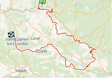

Length
104 km

Max alt
684 m

Uphill gradient
1864 m
Km-Effort
130 km

Min alt
213 m

Downhill gradient
2125 m
Boucle
No
Creation date :
2023-08-09 07:55:55.0
Updated on :
2023-08-09 17:43:38.265

FREE GPS app for hiking
 SityTrail
IGN / Geographical institutes
SityTrail Plus
The world is yours!
About
Trail of 104 km to be discovered at Occitania, Aveyron, Le Fel. This trail is proposed by Glurps.
Photos


Positioning
Country:
France
Region :
Occitania
Department/Province :
Aveyron
Municipality :
Le Fel
Location:
Unknown
Start:(Dec)
Start:(UTM)
460684 ; 4944494 (31T) N.
Comments